Showing 3028 items matching road maps
-
 Bendigo Historical Society Inc.
Map - Road maps
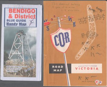
... Road maps...Road Map...Two road maps. On, Bendigo & District blue guide handy map...Road Map Victoria Bendigo On the back of the Bendigo map ...Two road maps. On, Bendigo & District blue guide handy map the other a road map of Victoria. On the back of the Bendigo map the date October 2000. On the Victoria map the words in pen "This doesn't belong to you, it is mine". L.J. Ellison and a blue stamp of Axedale service station. Aileen and John Ellison Collection.road map, victoria, bendigo -
 Bendigo Historical Society Inc.
Map - Three Road Maps of Bendigo, 1962
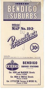
... Three Road Maps of Bendigo..., and was active in the Good Roads Movement. Next year he issued a road map...Three Road Maps of Bendigo, Bendigo and Suburbs, Bendigo..., and was active in the Good Roads Movement. Next year he issued a road map ...George Robert Broadbent (1863-1947), cyclist and map publisher, was born on 3 November 1863 at Ashby near Geelong, Victoria, son of George Adam Broadbent, Lancashire-born draper, and his wife Elizabeth, née Ruffhead. When the family moved to North Melbourne Broadbent attended the Errol Street school, followed his father's trade, and became an early cycling and cycle-racing enthusiast. At various times Broadbent held most Victorian and Australian road records, and two of his performances on solid tyres—203 miles (327 km) in 24 hours on a penny farthing, and 100 miles (161 km) in 6 hours 20 minutes on a 'safety' bicycle—were never bettered. He established records for all distances between 130 and 220 miles (209 and 354 km), and for all times between 8 and 12 hours, at the Exhibition Grounds track in May 1894, and road records for 50 and 100 miles (80 and 161 km) in October 1896. The Australian Cyclist acknowledged him 'the finest road rider that Australia has ever produced'. A foundation councillor of the League of Victorian Wheelmen in October 1893, Broadbent contested the first Warrnambool-Melbourne race in 1895, and was active in the Good Roads Movement. Next year he issued a road map of Victoria, 'prepared … after some sixteen years riding and touring in all parts of the Colony', which indicated general topography, distances, and roads classified as 'good', 'fair' or 'ridden with difficulty'. It was to become Victoria's standard map, and the basis of a continuous publishing programme by Broadbent's Official Road Guides Co.Three Road Maps of Bendigo, Bendigo and Suburbs, Bendigo and Eaglehawk. Two fold out maps printed in colour and produced by Broadbent's Road Maps Pty. Ltd. 475 Collins Street Melbourne. One map printed by Bolton's Bendigo.history, bolton's, bendio broadbent maps -
 Greensborough Historical Society
Road Maps, The Herald Road Guide, 1955-1956
... Road Maps...Book of road maps, 271 pages, in brown plastic carry case.... Plenty Lower Plenty melbourne Road Maps The Herald Road Guide ...Contains maps of Melbourne and surrounding areas as well as routes from Melbourne to other state capitals.Contains maps and descriptions of the Melbourne area in the era before the large scale urbanisation after 1960. Also includes country and day tour maps before highways were common.Book of road maps, 271 pages, in brown plastic carry case.maps, melbourne, victoria, day tours, touring maps -
 Greensborough Historical Society
Map, Broadbent's, Greensborough, 1953_
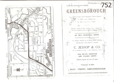
... road maps...This road map was a part of a Broadbent's Melbourne...A 1 page photocopy of a road map of Greensborough from 1953.... photocopy of a road map of Greensborough from 1953. Nil This road ...This road map was a part of a Broadbent's Melbourne suburban directory from 1953.It shows the lay out of Greensborough's streets in 1953.It also shows some different street names to those used today. It also features a C Jessop & Co. Real estate advertisementA 1 page photocopy of a road map of Greensborough from 1953.Nilgreensborough, c jessop, broadbents, map no 242, road maps, 1953 -
 Dutch Australian Heritage Centre Victoria
Road Map, Nederland
... Road Map...Cleverly folded 1:250,000 road map produced in Dutch...Falk Plan. Road Map. Netherlands. Repeated in Dutch... Carnegie melbourne Road Map Nederland Cleverly folded 1:250,000 ...Cleverly folded 1:250,000 road map produced in Dutch, French, German and English containing not only the Dutch road network but also much information of interest to tourists. It is enclosed in a brown imitation leather cover that closes with a stud. Optimal ease of use through patented Falk folding mode.Falk Plan. Road Map. Netherlands. Repeated in Dutch, French and German. -
 Marysville & District Historical Society
Photograph (Item) - Black and white photograph, 1949
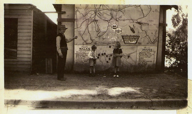
... atlantic road map...A copy of a black and white photograph of an Atlantic Road...A copy of a black and white photograph of an Atlantic Road.... A copy of a black and white photograph of an Atlantic Road Map ...A copy of a black and white photograph of an Atlantic Road Map of Marysville adhered to an unknown building in Marysville.A copy of a black and white photograph of an Atlantic Road Map of Marysville adhered to an unknown building in Marysville.marysville, victoria, maps, atlantic road map -
 Whitehorse Historical Society Inc.
Map, Nunawading Shire, 1892
... Covers Middleborough Road to Ringwood boundary. One map... boundary. One map (Blackburn) from north of Whitehorse Road.... Covers Middleborough Road to Ringwood boundary. One map ...Photocopy of an enlargement of map of Shire of Nunawading showing landowners in 1892.Photocopy of an enlargement of map of Shire of Nunawading showing landowners in 1892. Covers Middleborough Road to Ringwood boundary. One map (Blackburn) from north of Whitehorse Road to Highbury Road, 2nd map (Mitcham) Bulleen to south of Canterbury Road; 3rd map Whitehorse Road to Highbury Road.Photocopy of an enlargement of map of Shire of Nunawading showing landowners in 1892. maps, shire of nunawading, blackburn, blackburn south, nunawading, forest hill, vermont, mitcham, vermont south -
 Phillip Island and District Historical Society Inc.
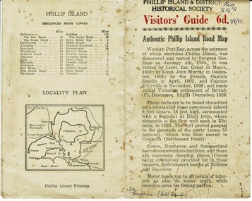
Booklet, Authentic Phillip Island Road Map, Pre 1960
... Authentic Phillip Island Road Map...Road map...Visitors' Guide 6d Authentic Phillip Island Road Map... Road Map Tourist brochure printed by the Phillip Island ...Tourist brochure printed by the Phillip Island Printers pre 1960HistoricalSmall cream coloured brochure with details of accommodation, transport and animals. Inside is a map of the Island with numbered points of interest. There is also a plan of Cowes and drawings of animals.Visitors' Guide 6d Authentic Phillip Island Road Maptourist brochure, road map -
Victorian Aboriginal Corporation for Languages
Book, Melway Publishing, Melway Greater Melbourne street directory : including Geelong, Phillip Island, Healesville, Kinglake, Gisborne, Lorne, Wallan, Bacchus Marsh, Bellarine &? Mornington Peninsulas, 2005
... road maps... Melbourne. maps maps Victorian street maps street directories road ...Street directory including the wider area surrounding Melbourne.mapsmaps, victorian street maps, street directories, road maps -
 Victorian Aboriginal Corporation for Languages
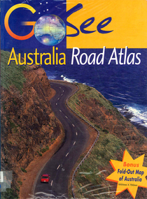
Book, Valerie Marlborough, Go see Australia road atlas, 2000
... road maps..., colour photographs atlases road maps Australian travel Valerie ...Contains state by state maps and details about each state.Maps, colour photographsatlases, road maps, australian travel -
 Victorian Aboriginal Corporation for Languages
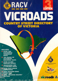
Book, Royal Automobile Club of Victoria, Vicroads country street directory of Victoria, 1997
... road maps..., and tourist information. Maps, colour photographs road maps Royal ...Country street directory which contains maps, lists, and tourist information.Maps, colour photographsroad maps -
 Kew Historical Society Inc
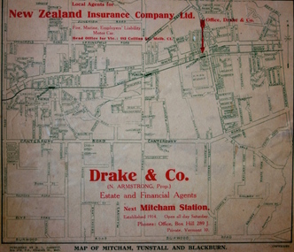
Map - Street Map, R L Jarrett, Map of Mitcham, Tunstall and Blackburn, 1929
... road maps... estate agents mitcham tunstall blackburn road maps drake & co new ...Tunstall was originally the name of Nunawading Railway Station. Tunstall opened on 4 June 1888 and was renamed on 1 November 1945. An historically significant advertising map that can be used to ascertain the extent of urban development in 1929 in the areas of Nunawading, Blackburn and Mitcham.A map of Mitcham, Tunstall and Blackburn found on the reverse of a real estate subdivision plan published by R. L. Jarrett of Elizabeth Street. This promotional street map is overprinted with the business address of the sponsors and advertising. Map overlaid in red print: "Drake & Co. / (N. Armstrong, Prop.) / Estate and Financial Agents / next Mitcham Station / Established 1914. Open all day Saturday. / Phones: Office, Box Hill 289 J. / Private, Vermont 10."real estate agents, mitcham, tunstall, blackburn, road maps, drake & co, new zealand insurance co ltd -
Canterbury History Group
Document - Frognall - History, Royal Australian Air Force
... > Clarence Laycock> Burdett Frognall Mont Albert Road Maps Elgar's ...Photocopy of a 38 page booklet compiled by Royal Australian Air Force Engineers Cadet Squadron , includes maps, house floor plan, photographs and footnotescanterbury, royal australian air force engineers cadet squadron, hicks> clarence, laycock> burdett, frognall, mont albert road, maps, elgar's special survey -
Canterbury History Group
Document - The Grange, 1905
... The Grange Fintona Junior School St. Duthies Mont Albert Road Maps ...MMBW detailed map of "The Grange" 1905. Includes a short history of the house by Don Gibbcanterbury, the grange, fintona junior school, st. duthies, mont albert road, maps -
 City of Moorabbin Historical Society (Operating the Box Cottage Museum)
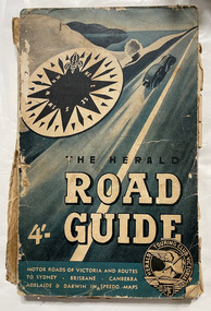
Book, Herald Touring Club (Victoria), The Herald road guide, 1950s
... road maps...Book The Herald road guide 1 atlas (224 p.), 1 folded map ...Map of southeastern Australia, Adelaide to Brisbane, showing roads and distances, with chief detail about Victoria. Includes strip maps, itinerary guides, and index. Issued by the Herald Touring Club, with new district and city maps surveyed by the Club.1 atlas (224 p.), 1 folded map : ill., maps ; non-fictionMap of southeastern Australia, Adelaide to Brisbane, showing roads and distances, with chief detail about Victoria. Includes strip maps, itinerary guides, and index. Issued by the Herald Touring Club, with new district and city maps surveyed by the Club.automobile travel, road maps, herald touring club -
Federation University Historical Collection
Map, Robinson's Ballarat Street Map, c1972, 1970s
... includes a district road map.... of Ballarat. It also includes a district road map. ballarat map ...A coloured fold-out street map of Ballarat. It also includes a district road map.ballarat, map, ballarat streets -
 Bendigo Military Museum
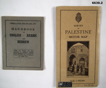
Booklet - HANDBOOK & ROAD MAP, April 1940
... HANDBOOK & ROAD MAP... in the Middle East. 2. Palestine Road Map. It has cardboard cover... goldfields HANDBOOK & ROAD MAP Booklet 1. This is a small pocket book ...Sold by Ringarts Bookshop, Haifa1. This is a small pocket book, grey cover, black ink printing. It has words and phrases of colloquial Arabic and/or Hebrew. 32 pages. It is for Australian Imperial Forces in the Middle East. 2. Palestine Road Map. It has cardboard cover and opens out to a road map, scale 1:500,000. It has a drawing of the old section of Jerusalem on front cover.passchendaele barracks trust, 1. nr9430t, 2.9431t, ww2 -
Whitehorse Historical Society Inc.
Map, Site for Wesleyan Church, Nunawading, 1855
... Whitehorse Historical Society Inc. 2-10 Deep Creek Road ...Photocopy of manuscript map showing names of landholders.Photocopy of manuscript map showing names of landholders. Note on verso: Plan of allotments in the City of Melbourne appropriated to the Wesleyans. Site for Wesleyan Church, Nunawading 1848 (Corner of Burwood and Elgar Roads - S of Burwood, W of Elgar)Photocopy of manuscript map showing names of landholders. churches, wesleyan church, burwood, burwood road, burwood, elgar road, burwood, maps -
 Melbourne Tram Museum
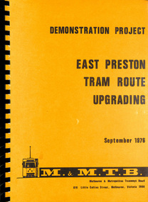
Document - Report, Melbourne & Metropolitan Tramways Board (MMTB), "Demonstration Project - East Preston Tram route upgrading Sept. 1976", Sep. 1976
... Preston Traffic Control Traffic Lights Delays Road Works Maps ...Report - A4, 170 pages + card coves with plastic sheets black comb bound, titled "Demonstration Project - East Preston Tram route upgrading Sept. 1976" Has a Table of Contents, appendices, photograph, tables and diagrams. Looks at the delays on the East Preston route with methods of overcoming the bunching of trams, installation of kerbs for trams, traffic island, coordinated traffic lights along with Project costs. Notes it is a demonstration project.trams, tramways, mmtb, tramways, melbourne, surveys, passengers, east preston, traffic control, traffic lights, delays, road works, maps -
Port Melbourne Historical & Preservation Society
Map - VACCUUM Road Guide to Victoria
... map. VACCUUM Road Guide to Victoria... Motor car purchases, Registration, Licences & RACV Road map ...The Mathews family have been in continuous ownership of 395 Howe Parade (was 8 Howe Parade until 1964 when addresses re-assigned), Port Melbourne from 1938 to the present (Sept 2019)Six folders of assorted documents relating to the life of Alan Mathews and his family. Employment documents. Folder 4 has Motor car purchases, Registration, Licences & RACV Road map. VACCUUM Road Guide to Victoriatransport - motor vehicles, alan mathews, commonwealth aircraft corporation, cac -
Southern Sherbrooke Historical Society Inc.
Information folder - Belgrave Heights Convention Ground
... , "Belgrave District Road Map" showing locations in Belgrave Heights... Road Map" showing locations in Belgrave Heights & South -map ...Information folder containing items pertaining to the history of the Belgrave Heights Convention Grounds. Contents: -map, "Belgrave District Road Map" showing locations in Belgrave Heights & South -map "Belgrave Heights Road Map" showing Convention Grounds, buildings and other local sites -Various items photocopied on single sheet, inc. token for Gospel Supplies, Belgrave Heights; item re. Rudi Atwood, minister; list of hymns; photo of Main St, Belgrave. -
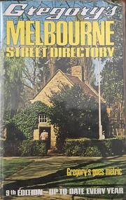 Kew Historical Society Inc
Book, Gregory's Publishing Company Pty Ltd, Gregory's Street Directory of Melbourne and suburbs and Metropolitan Road Guide, 1971
... of road maps of Melbourne and its suburbs, newly extending... a series of road maps of Melbourne and its suburbs, newly extending ...Street DirectoryRevised edition of Gregory's Directory including a series of road maps of Melbourne and its suburbs, newly extending to Lilydale, Mornington, Laverton, Deer Park, Epping, Diamond Creek, Olinda, Belgrave, and Doveton.non-fictionStreet Directorystreet directories - melbourne, gregory's street directories -
![Booklet, Souvenir of Phillip Island [Cowes, Rhyll, Newhaven etc] and San Remo, Late 1920s. Post 1926](https://victoriancollections.net.au/media/collectors/4f729f5b97f83e0308601629/items/6462d05d551955aaca8bbecf/item-media/6462d125551955aaca8c0867/item-fit-380x285.jpg) Phillip Island and District Historical Society Inc.
Phillip Island and District Historical Society Inc.Booklet, Souvenir of Phillip Island [Cowes, Rhyll, Newhaven etc] and San Remo, Late 1920s. Post 1926
... to Broadbent's Road Maps Pty. Ltd. Broadbent's company produced many..., it changed its name to Broadbent's Road Maps Pty. Ltd. Broadbent's ...Broadbent's Official Road Guides Company took over George R. Broadbent's business in 1935. In 1963, it changed its name to Broadbent's Road Maps Pty. Ltd. Broadbent's company produced many maps, road and tourism guides of Australia.HistoricalSmall, beige coloured booklet with blue print and round photo of S.S.Alvina at Cowes jetty on cover. Advertisement for Westernport Steamer Service on rear page. Contains descriptions of main towns and places of interest. Also advertisements for guesthouses, businesses and tourist guides.Broadbent's Holiday Guide to Phillip Island and San Remo. [alternative title]tourist brochure, souvenir, broadbent's guides, phillip island accommodation, ferries, maps, guesthouses, hotels, shops -
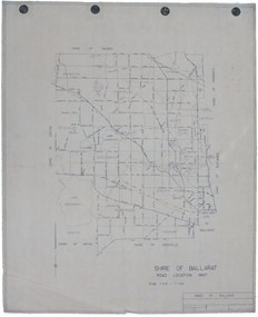 Federation University Historical Collection
Map, Shire of Ballarat Road Location Map, 1968, 05/06/2014
... Shire of Ballarat Road Location Map, 1968...White paper road location map. Scale 1 mile to 1 inch... Shire of Ballarat Road Location Map, 1968 White paper road ...White paper road location map. Scale 1 mile to 1 inchballarat, shire of ballarat, roads, dowling forest, lake burumbeet, lake learmonth, ascot, windermere, tourello -
Canterbury History Group
Map - Maling Road Urban Renewal Map 1972, 1972
... Maling Road Urban Renewal Map 1972... melbourne Maling Road Urban Renewal Map 1972 Map Photocopy of map ...Photocopy of map of proposed urban renewal in Maling Road Canterbury 1971canterbury, maling road, town planning, maps -
Canterbury History Group
Document - Thematic Environmental History, Built Heritage, 1/05/2012 12:00:00 AM
... Boot Factory Land Subdivisions Maling Road Malone's Hotel Maps ...Thematic Environmental Heritage. Final document produced, after community consultation, for the City of Boroondara by Built Heritage.city of boroondara, back yards, canterbury, canterbry road, churches, cottages, dairies, danks family, elgar survey, exploration, frognall, goldings boot factory, land subdivisions, maling road, malone's hotel, maps, masonic lodges, national parks, native plants, outer circle railway line, parks and reserves, police stations, post offices, railways, rochester road, schools, shrublands, soldiers memorial hall, sport, telephone exchanges, theatres, transport, wildlife -
 Glen Eira Historical Society
Document - NEERIM ROAD RAILWAY CROSSING AND GATES GLEN HUNTLY
... Professionals Traffic Road Transport Transport Maps Documents Plans ...This file contains two items: 1/Twelve photographs of the Glen Huntly, Neerim Road hand-operated railway gates, dated 1983 and November 1985, photographer unknown, and two black and white copies of two of the original photographs. Four photographs are in black and white and eight are in colour, all picturing the Gatekeeper’s shelter and/or the railway gates. Six photographs dated 1985 include the Gatekeeper, unidentified, in some photos operating the gates. 2/A three-page pamphlet dated 03/05/1979 promoting a public meeting at the Caulfield Town Hall to debate Road Grade Separation proposals for the Neerim Road and Glenhuntly Road railway crossings. Document details the proposed VicRail improvement and four alternative improvements as we as a blank questionnaire for the submission of ideas regarding the proposals to the Caulfield City Council Urban Planner. A short summary of other concerns held by two councillors and an engineer regarding the proposal is also included, as is a Railway Noise Level. Railway Pamphlet also includes a map of the area surrounding the railway crossings under discussion 1977.glenhuntly road, neerim road, caulfield, railway gates, gates, hand-operated railway gates, railways, roads and streets, railway crossings, architectural features, town halls, official buildings, vicrail, meetings, public meetings, caulfield town hall, gatekeepers, caulfield city council, elsternwick, glen huntly, caulfield park, caulfield racecourse, normanby road, dandenong road, railway buildings, railway stations, land transport, transport establishments, hordern a.g., dunstan don, hordern bill, needham j.g., advertisements, graphics, advertising, advertising signs, signs, estate agents, business people, stockdale and leggo, buildings structures and establishments, occupations, united signs, signs, communication devices, motor vehicles, glenhuntly railway station, town planning, civic and landscape art, engineers, professionals, traffic, road transport, transport, maps, documents, plans -
Glenelg Shire Council Cultural Collection
Map - Map - RACV Road Map, 1970s
... Map - RACV Road Map... road map...RACV road map, Warrnambool District, Port Fairy to Lorne... Cliff Street Portland great-ocean-road Map - RACV Road Map Map ...RACV road map, Warrnambool District, Port Fairy to Lorne. Large coloured map of Warrnambool District. Small maps of Apollo Bay, Colac, Camperdown, Tower Hill and Warrnambool. When folded, black and white photo on cover of 12 Apostlesracv, road touring, road map, victoria -
Federation University Historical Collection
Map, City of Ballarat and Borough of Sebastopol Road Map
... City of Ballarat and Borough of Sebastopol Road Map...Road map of the City of Ballarat and the Borough... City of Ballarat and Borough of Sebastopol Road Map Road map ...Road map of the City of Ballarat and the Borough of Sebastopol. WGS 85 Centroid 37 degrees 33 feet 56 inches south 143 degrees 51 feet 09 inches eat E-W- extent: 9 km N-S- extent: 11.5 kmballarat, sebastopol, map, plan, ballarat shire -
Whitehorse Historical Society Inc.
Map, Parish of Nunawading, 1892
... Lithographed by G.S. Bonne[y]. Map includes roads...Map copied from 'Directory maps - parishes and counties... by G.S. Bonne[y]. Map includes roads, railway, stations, names ...Map copied from 'Directory maps - parishes and counties' 26 Nov 1892.Map copied from 'Directory maps - parishes and counties' 26 Nov 1892. Lithographed by G.S. Bonne[y]. Map includes roads, railway, stations, names of property owners. 2nd copy 'for copying'.Map copied from 'Directory maps - parishes and counties' 26 Nov 1892. maps, parish of nunawading